Submitted by skishark, private e-mail welcome : skishark@hotmail.com
BBRRRR, Wouldn't want to be up there
right about now.
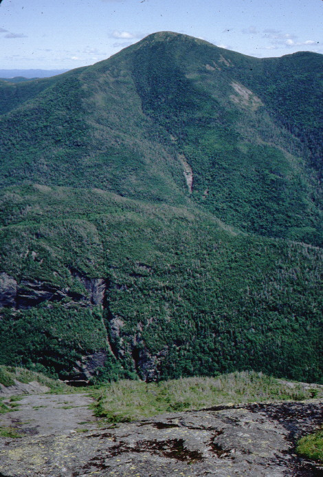
This is Mount Algonquin, as seen from the summit of Mt. VanHovenberg
while a summer sun-shower sparkles it.
Dear Friends,
I told many of you I would
write a letter about the
adventure to be had
climbing Algonquin. Here it is.
Algonquin is the second
highest mountain in
New York State. at 5114 feet
in altitude, it is exceeded only
by Mount Marcy and is more
fun to climb. I have climbed
it five times since I was
thirteen and have decided
late spring is the best time.
Perhaps mid to late May,
The snow has melted and run
off, the trails are clear
and have good footing, and
the bugs aren't up to their
yearly peak yet.
Algonquin is a part of the McIntyre range, named for Archibald McIntyre,
one time master of the iron works by that name. The mountains that make
up the range are Algonquin, Wright, Boundary, Marshall and Iroquois,
also a smallish hummock known as Whale's Tail.
There is an interesting bit of folklore associated with how some
of these names were arrived at. Way back in the past, Indians used
to use the Adirondack mountains as their hunting ground. When the
Algonquins from the north and the Iroquois from the Mohawk Valley met,
they usually had a fight. This fighting interfered with the hunting.
so a truce-treaty was arrived at. One mountain was named Boundary, and was.
The big mountain to the north of it was called Algonquin, and the big
mountain to the south of Boundary was called Iroquois. The boundary
described the Indian hunting grounds, and thus a form of peace settled
on northern New York.
The foot trail up Algonquin, at least the foot trail that is an easy day
hike, leaves from the Heart Lake parking lot. It is about four miles from there
to the top of the mountain. After about one mile a junction of three more trails
is reached. To the right is back to Heart Lake, through the campsite, not by
the elementary easy trail it's been so far. To the left is a trail up Mount Marcy,
7.63 miles, much of it swampy, Straight ahead is up Algonquin. At about two
and a half miles a beautiful waterfall is passed on the left. This is Mcintyre
brook, rushing down to Heart Lake. This a good place to take a break and
wait for the laggers in our group. It is not difficult to climb this waterfalls,
about fifty feet, to enjoy the first wild Adirondack view of the day.
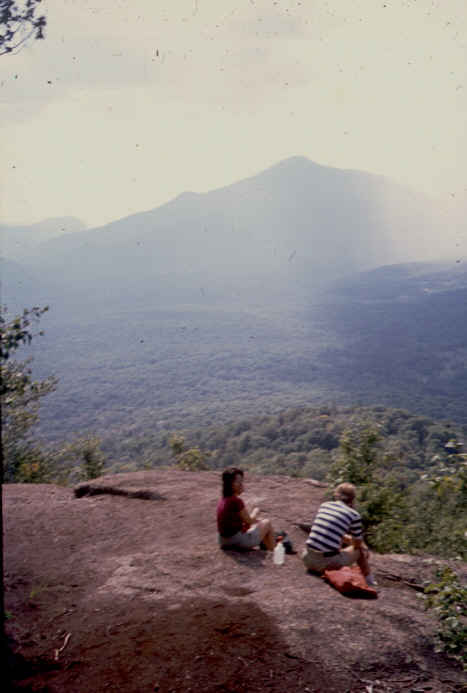
The climbing is not difficult so far. About three miles you may notice a
rock outcropping off the trail to the right. This is fun to climb, almost vertical,
about one hundred feet. The view is fantastic up there. Many high peaks, and
Indian Pass is spottable, as seen in this photo. Blueberries grow wild.
 There is a short level place
but the trail grows steeper.
Just after three miles there
is the junction with the trail
up Wright peak,to the left up
about half a mile . A small
stream here provides the last
water. The trail now is
steadily steep as you
approach timberline. This is a
good test of personal
endurance. Up from the
waterfall, up to the
outcropping, up to timberline,
and finally up to the summit.
 I guarantee good feelings
will be had if we reach the
summit. Walking around near
the summit is great good fun.
High altitude and being a
little out of breath, the alpine
vegetation and the great
views of distant peaks
all combine to produce an
unforgettable enjoyment.
We usually eat lunch on top
as we contemplate the view.
Many fine mountains can be
seen from the summit of
Algonquin. This photo is
Mt. Marcy from the summit,
Mt. Colden in front, with the
trap dyke writhing up from
Avalanche Lake. Just a sliver
of Avalanche Lake can be
seen at the bottom of the
picture.
Mt Colden, Gray peak, Hough and Dix, Mount Marcy with the great Range
stretching away from the northeast of Marcy, Whiteface and Giant can
also be seen.
In order to travel light, my lunch usually is made up of beef jerky, pecans, dried
apricots, and a candybar. Canned sardines and crackers is a common substitute.
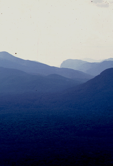
Sometimes the weather doesn't agree to co-operate.
It may be cloudy and distant mountains can't be seen. It may be windy or very
cold. Weather may be falling from the sky.
What you should have with you for this climb and many others. Good
shoes that will leave your feet feeling comfortable after a ten mile hike over
rough rocks. A small knapsack, often known as a day pack, to carry your
essentials. A stout windbreaker, hat and gloves to combat the cold.
Something to eat for lunch, a water bottle, about 1 qt., a folding knife,
compass, pen light, whistle, insect repellent and bandanna. You should have a
little box containing minimal essentials for first aid, mole skin for your feet,
band-aids, elastic bandage if you should hurt a knee or ankle, a pillbox with
cold pills ,antacid, and aspirin. . .
If you expect to climb Mount Algonquin, you need to drive to where the
footpath for day hikers begins. There are longer trails up Algonquin, but the
best footpath that makes it a day hike leaves from Heart Lake. Get on Route
87 ( the Northway) drive north a few miles and exit at Route 73. Drive north
on Route 73; (enjoy views of the heart of the high-peaked Adirondacks)
through Keene Valley and Keene. About five miles from the town of Lake
Placid there is a road on the Left, going south to Heart Lake, marked with a
sign. There is a parking lot at Heart Lake. There is also a campground,
swimming area, lodge run by the Adirondack Mountain Club, museum run by
the park rangers, a store selling hiker's needs and many trailheads. The
parking lot charges a parking fee. If you wish to minimize driving, let me
know and then park on Route 8 north of Utica, we can probably pick you up
and then drop you off at your car after a day of serious fun. From Heart Lake
it is about four miles to the top of Algonquin. Let me know if you have any
other questions about this thoroughly enjoyable climb
What to expect on this trip:To spend a day on Algonquin, we usually
leave our home at about 5 AM and start hiking about 9 AM. Typical
mountain climbing speed is about one mile an hour, this gets us to the top
sbout 1:00 PM We'll spend about half an hour there, and start down about
1:30. Down is faster than up. We get back to the parking lot about 4:00 PM
and shortly drive away. We can stop for dinner in one of the restaurants in
Keene Valley. We'll really enjoy the meal, and any hikers who are there.
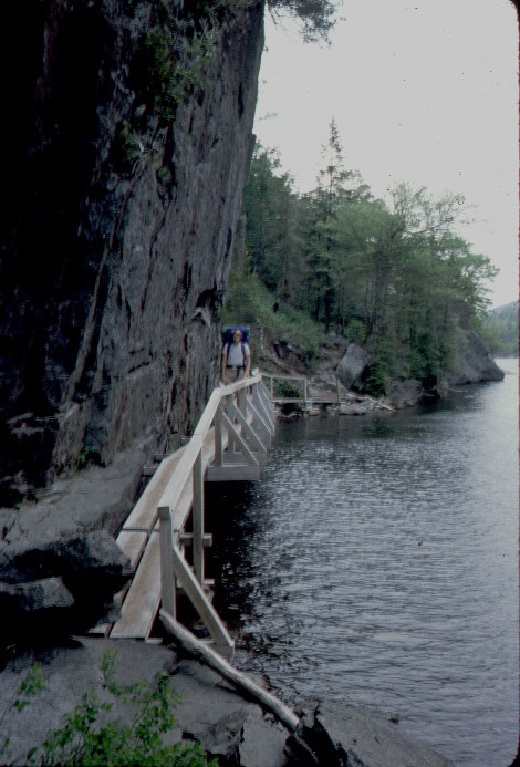
Here is my friend John on the 'hitch-up-matilda', a footbridge
on the trail along the north shore of Avalanche Lake. More photos such as this
can be viewed at Skishark's homepage:
www.geocities.com/skisharks